|
Table of Contents |
|
Saturn's Moons |
|
Atlas,
Calypso,
Dione,
Enceladus,
Epimetheus,
Helene,
Hyperion,
Iapetus,
Janus,
Mimas,
Pan,
Pandora,
Phoebe,
Prometheus,
Rhea,
Telesto,
Tethys,
Titan,
Possible New Satellites |
|
Saturn Science |
The European Space Agency's (ESA's) Huygens probe, carried to Saturn by the Cassini spacecraft, parachuted to the surface of Saturn's giant moon Titan on Friday, Jan. 14th, revealing finally what lies beneath Titan's thick orange clouds.
First images released by the ESA depict sinuous drainage channels leading to an apparent shoreline. What's draining? Possibly liquid methane. The orange landscape around the Huygens landing site is littered with little rocks, rounded and smooth like river-rocks on Earth. One of the images seems to show tendrils of ground fog made not of water but perhaps ethane or methane.
It's all a bit familiar, yet at the same time utterly alien. Researchers are elated.
|
|
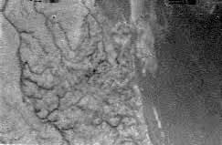
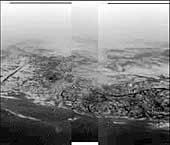
Right: From an altitude of 16 km, Huygens photographed these drainage channels leading to a shoreline. [ More ] |
Because Titan has a thick atmosphere, able to carry sound waves, the moon is a noisy place. Microphones onboard Huygens recorded the sound of wind rushing by the probe as it descended. The ESA has released about one minute's worth of the recording; it's a sample of what a traveler riding with Huygens would have heard during the descent: click here to listen.
Huygens was designed to float in case it landed in a river or lake--but it didn't. After descending by parachute for two and a half hours, the saucer-shaped probe hit solid ground at a speed of 4.5 meters per second (10 mph), experiencing a brief jolting deceleration of 15 Gs. Huygens survived the impact and continued transmitting data for more than one hour after landing.
Among the measurements sent back to Earth were air temperature, pressure, composition and wind speed sampled at points ranging from the top of Titan's atmosphere to the ground. The temperature of the landing site itself was minus 291 degrees F. A "penetrometer" on the bottom of the probe poked into the ground. The soil, it found, has the consistency of wet sand or clay and is covered by a thin crust ... of something. Scientists are still analyzing all these data.
|
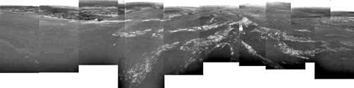
| A 360o panoramic view of the terrain around Huygens' landing site. Scientists speculate that the white streaks are a ground 'fog' of methane or ethane vapor. [ More ] |
There are enough photos, sounds and other measurements to keep researchers busy for years. The data released so far are preliminary, just a fraction of the total. Stay tuned for more....
Sounds of Titan
Speeding through Titan's hazeThis recording is a laboratory reconstruction of the sounds heard by Huygens' microphones. Several sound samples, taken at different times during the descent, are here combined together and give a realistic reproduction of what a traveller on board Huygens would have heard during one minute of the descent through Titan's atmosphere. File 1 : acoustic during descent
Radar echos from Titan's surface
This recording was produced by converting into audible sounds some of the radar echoes received by Huygens during the last few kilometres of its descent onto Titan. As the probe approaches the ground, both the pitch and intensity increase. Scientists will use intensity of the echoes to speculate about the nature of the surface.
File 2 : radar conversion
Pictures of Titan
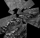
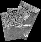 Mosaic of River Channel and Ridge Area on Titan
This mosaic of three frames from the Huygens Descent Imager/ Spectral Radiometer (DISR) instrument provides unprecedented detail of the high ridge area including the flow down into a major river channel from different sources.
The Descent Imager/Spectral Radiometer is one of two NASA instruments on
the probe.
(Courtesy ESA/NASA/JPL/University of Arizona)
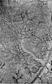
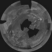 Huygens Titan Mosaic #1
This stereographic projection of Descent Imager/Spectral Radiometer images
from the European Space Agency's Huygens probe combines 60 images in 31
triplets, projected from a height of 3,000 meters (9,843 feet) above the
black 'lakebed' surface. The bright area to the north (top of the image)
and west is higher than the rest of the terrain, and covered in dark lines
that appear to be drainage channels.
The images were then stitched together using one of several projection algorithms (in this case 'stereographic') to produce a full mosaic. The images used to construct this mosaic were taken on Jan. 14, 2005.
The Descent Imager/Spectral Radiometer is one of two NASA-funded
instruments on the probe.
(Courtesy NASA/JPL/ESA/University of Arizona)
 Huygens Titan Mosaic #2
This mosaic from the Descent Imager/Spectral Radiometer camera on the
European Space Agency's Huygens probe combines 17 image triplets,
projected from an altitude of 800 meters (2,625 feet). The area covered
is approximately 1,300 meters (4,265 feet) across (north at the top of
the image). The smallest visible objects visible are less than five meters
(16 feet) across, and the dark channels are 30 to 40 meters (98 to 131
feet) wide.
The images were then stitched together using one of several projection algorithms (in this case 'gnomonic') to produce a full mosaic. The images used to construct this mosaic were taken on Jan. 14, 2005.
The Descent Imager/Spectral Radiometer is one of two NASA-funded
instruments on the probe.
(Courtesy NASA/JPL/ESA/University of Arizona)
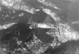
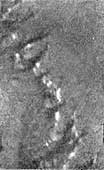 'Islands' on a Dark Plain
A single image from the Huygens Descent Imager/ Spectral Radiometer
(DISR) instrument of a dark plain area on Titan, seen during descent to
the landing site, that indicates flow around bright 'islands'. The areas
below and above the bright islands may be at different elevations.
The Descent Imager/Spectral Radiometer is one of two NASA instruments on
the probe.
(Courtesy ESA/NASA/JPL/University of Arizona)
 Water Ice and Methane Springs
A single Huygens Descent Imager/ Spectral Radiometer (DISR) instrument
image shows two new features on the surface of Titan. A bright linear
feature suggests an area where water ice may have been extruded onto the
surface. Also visible are short, stubby dark channels that may have been
formed by 'springs' of liquid methane rather than methane 'rain'.
The Descent Imager/Spectral Radiometer is one of two NASA instruments on
the probe.
(Courtesy ESA/NASA/JPL/University of Arizona)
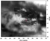 Titan Landing Site Seen From Cassini
A view of Titan from the visual and infrared mapping spectrometer
instrument on the Cassini orbiter. The Huygens probe landed in the small
red circle on the boundary of the bright and dark regions. The size of
the circle shows the field of view of the Huygens Descent Imager/Spectral
Radiometer (DISR) instrument from an altitude of 20 kilometers (about 12
miles).
(Courtesy NASA/JPL/University of Arizona/USGS)
 Varied Terrain
This composite was produced from images returned yesterday, January 14, 2005, by the European Space Agency's Huygens probe during its successful descent to land on Titan. It shows the boundary between the lighter-colored uplifted terrain, marked with what appear to be drainage channels, and darker lower areas.
These images were taken from an altitude of about 8 kilometers (about 5 miles) and a resolution of about 20 meters (about 65 feet) per pixel. The images were taken by the Descent Imager/Spectral Radiometer, one of two NASA instruments on the probe.
(Courtesy ESA/NASA/Univ. of Arizona)
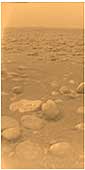 First Color View of Titan's Surface
This image was returned yesterday, January 14, 2005, by the European Space Agency's Huygens probe during its successful descent to land on Titan. This is the colored view, following processing to add reflection spectra data, and gives a better indication of the actual color of the surface.
Initially thought to be rocks or ice blocks, they are more pebble-sized. The two rock-like objects just below the middle of the image are about 15 centimeters (about 6 inches) (left) and 4 centimeters (about 1.5 inches) (center) across respectively, at a distance of about 85 centimeters (about 33 inches) from Huygens. The surface is darker than originally expected, consisting of a mixture of water and hydrocarbon ice. There is also evidence of erosion at the base of these objects, indicating possible fluvial activity.
The image was taken with the Descent Imager/Spectral Radiometer, one of two NASA instruments on the probe.
(Courtesy ESA/NASA/Univ. of Arizona)
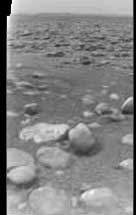 Rocks on the Surface of Titan
This raw image was returned by the Descent Imager/Spectral Radiometer camera
onboard the European Space Agency's Huygens probe after the probe descended
through the atmosphere of Titan. It shows the surface of Titan with ice blocks
strewn around.
(Courtesy ESA/NASA/University of Arizona)
 Black and White Image of Titan's Surface
This is one of the first raw images returned by the European Space Agency's Huygens probe during its successful descent to Titan. It was taken from an altitude of 16.2 kilometers with a resolution of approximately 40 meters per pixel. It apparently shows short, stubby drainage channels leading to a shoreline.
It was taken with the Descent Imager/Spectral Radiometer, one of two NASA
instruments on the probe.
(Credit: ESA/NASA/University of Arizona)