|
COMETS EARTH JUPITER KUIPER BELT MARS MERCURY METEORITES NEPTUNE OORT CLOUD PLUTO SATURN SOLAR SYSTEM SPACE SUN URANUS VENUS ORDER PRINTS
PHOTO CATEGORIES SCIENCEVIEWS AMERICAN INDIAN AMPHIBIANS BIRDS BUGS FINE ART FOSSILS THE ISLANDS HISTORICAL PHOTOS MAMMALS OTHER PARKS PLANTS RELIGIOUS REPTILES SCIENCEVIEWS PRINTS
|
Related Documents
Download Options
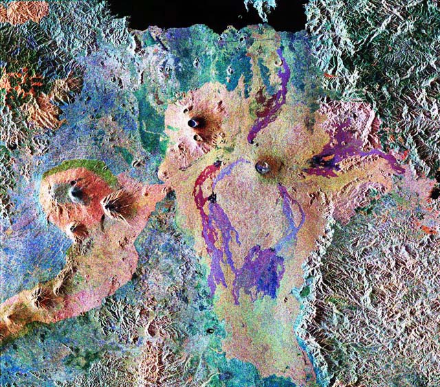
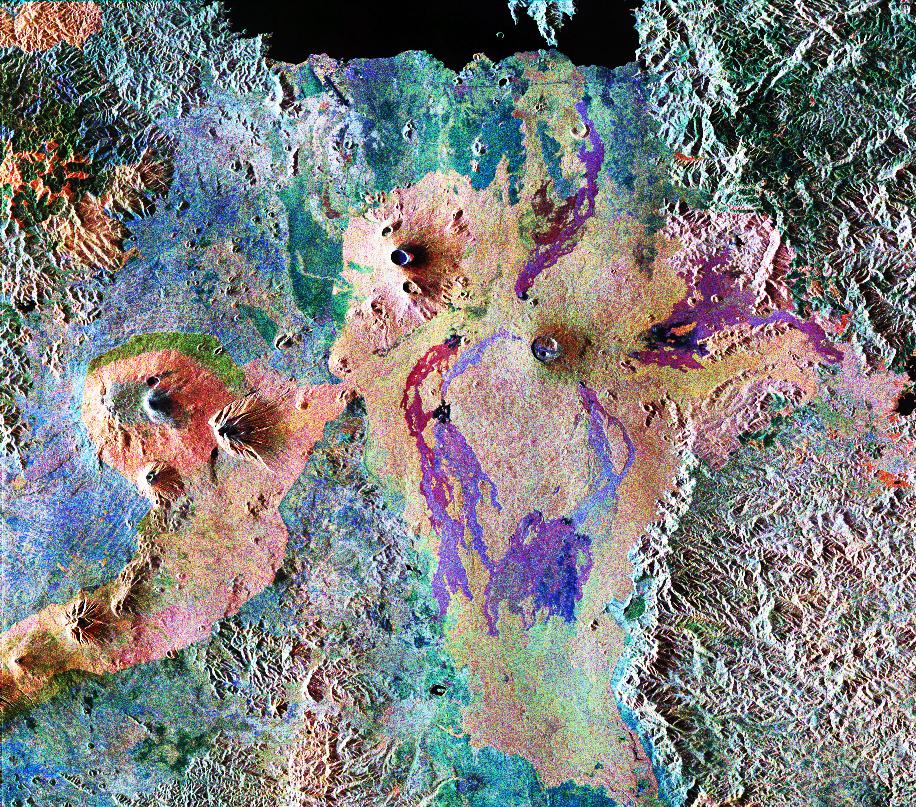
This is a false-color composite of Central Africa, showing the Virunga volcano chain along the borders of Rwanda, Zaire and Uganda. This area is home to the endangered mountain gorillas. The image was acquired on October 3, 1994, on orbit 58 of the space shuttle Endeavour by the Spaceborne Imaging Radar-C/X-band Synthetic Aperture Radar (SIR-C/X- SAR). In this image red is the L-band (horizontally transmitted, vertically received) polarization; green is the C-band (horizontally transmitted and received) polarization; and blue is the C-band (horizontally transmitted and received) polarization. The area is centered at about 2.4 degrees south latitude and 30.8 degrees east longitude. The image covers an area 56 kilometers by 70 kilometers (35 miles by 43 miles). The dark area at the top of the image is Lake Kivu, which forms the border between Zaire (to the right) and Rwanda (to the left). In the center of the image is the steep cone of Nyiragongo volcano, rising 3,465 meters (11,369 feet) high, with its central crater now occupied by a lava lake. To the left are three volcanoes, Mount Karisimbi, rising 4,500 meters (14,800 feet) high; Mount Sabinyo, rising 3,600 meters (12,000 feet) high; and Mount Muhavura, rising 4,100 meters (13,500 feet) high. To their right is Nyamuragira volcano, which is 3,053 meters (10,017 feet) tall, with radiating lava flows dating from the 1950s to the late 1980s. These active volcanoes constitute a hazard to the towns of Goma, Zaire and the nearby Rwandan refugee camps, located on the shore of Lake Kivu at the top left. This radar image highlights subtle differences in the vegetation of the region. The green patch to the center left of the image in the foothills of Karisimbi is a bamboo forest where the mountain gorillas live. The vegetation types in this area are an important factor in the habitat of mountain gorillas. Researchers at Rutgers University in New Jersey and the Dian Fossey Gorilla Fund in London will use this data to produce vegetation maps of the area to aid in their studies of the last 650 mountain gorillas in the world. The faint lines above the bamboo forest are the result of agricultural terracing by the people who live in the region. Spaceborne Imaging Radar-C and X-Synthetic Aperture Radar (SIR-C/X-SAR) is part of NASA's Mission to Planet Earth. The radars illuminate Earth with microwaves, allowing detailed observations at any time, regardless of weather or sunlight conditions. SIR-C/X-SAR uses three microwave wavelengths: L-band (24 cm), C-band (6 cm) and X-band (3 cm). The multi- frequency data will be used by the international scientific community to better understand the global environment and how it is changing. The SIR-C/X-SAR data, complemented by aircraft and ground studies, will give scientists clearer insights into those environmental changes which are caused by nature and those changes which are induced by human activity. SIR-C was developed by NASA's Jet Propulsion Laboratory. X-SAR was developed by the Dornier and Alenia Spazio companies for the German space agency, Deutsche Agentur fuer Raumfahrtangelegenheiten (DARA), and the Italian space agency,Agenzia Spaziale Italiana (ASI), with the Deutsche Forschungsanstalt fuer Luft und Raumfahrt e.V. (DLR), the major partner in science, operations and data processing of X-SAR. This image is in the public domain and is copyright free. |
