|
COMETS EARTH JUPITER KUIPER BELT MARS MERCURY METEORITES NEPTUNE OORT CLOUD PLUTO SATURN SOLAR SYSTEM SPACE SUN URANUS VENUS ORDER PRINTS
PHOTO CATEGORIES SCIENCEVIEWS AMERICAN INDIAN AMPHIBIANS BIRDS BUGS FINE ART FOSSILS THE ISLANDS HISTORICAL PHOTOS MAMMALS OTHER PARKS PLANTS RELIGIOUS REPTILES SCIENCEVIEWS PRINTS
|
Related Documents
Download Options
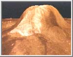
This animation was taken from the NASA movie Magellan: Mapping the Planet Venus (CMP 399). It was digitized by Calvin J. Hamilton.
DescriptionThis computer generated animation creates a simulated flight over the western portion of Eistla Regio - a broad 1380 by 1200 mile region of Venus. Many of the features we see may be the result of hot material upwelling from the interior of the planet.Magellan radar images are combined with altimetry to create a three dimensional map of the surface. Radarclinometry and simulated color are used to enhance the small scale structure of the surface features. Our flight begins with a view of Sif Mons (a 1.2 mile high volcano). We fly over a rift valley, several impact craters, a corona and Gula Mons (a 1.8 mile high volcano). The flight ends with a northeast view of Eistla Regio. Computer animation techniques were used to create this simulated flight over the surface of Venus. This video sequence uses radar mapping data recorded by the Magellan spacecraft during September 1990 to February 1991. Simulated color approximates hues which might be seen by the human eye, based on color images recorded by the Venera 13 and 14 spacecraft. The brightness variations are due to changes in roughness, slope and composition. The vertical scale of this flight is exaggerated by a factor of 22.5. Five mosaics of radar images from selected orbits were used to create this animation sequence. |