|
COMETS EARTH JUPITER KUIPER BELT MARS MERCURY METEORITES NEPTUNE OORT CLOUD PLUTO SATURN SOLAR SYSTEM SPACE SUN URANUS VENUS ORDER PRINTS
PHOTO CATEGORIES SCIENCEVIEWS AMERICAN INDIAN AMPHIBIANS BIRDS BUGS FINE ART FOSSILS THE ISLANDS HISTORICAL PHOTOS MAMMALS OTHER PARKS PLANTS RELIGIOUS REPTILES SCIENCEVIEWS PRINTS
|
Related Documents
Download Options
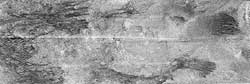
This image is a portion of the swath acquired by the Cassini Titan radar mapper on Feb. 15, 2005, on the mission's second opportunity to image the surface with radar. The frame, measuring about 300 kilometers (186 miles) from top to bottom, shows an area near the northeast corner of the large optically bright region named Xanadu. Running across the image are a series of roughly parallel, mostly east-west dark linear features that join and separate, which are not seen in the previous radar images. They may be formed by the action of eastward-flowing winds, or geologic processes acting on the crust itself. In places they cut through adjacent terrain, while elsewhere the lineaments seem to be interrupted by brighter material, appearing again on the other side. Seams between radar segments are visible as horizontal, sawtooth-shaped lines. Bright material in radar images may be rough or sloped toward the radar (which is observing from the top in this frame). Also, some of what is seen may in fact be below the surface, revealed as the radio waves penetrate overlying, radar-transparent material. |