|
COMETS EARTH JUPITER KUIPER BELT MARS MERCURY METEORITES NEPTUNE OORT CLOUD PLUTO SATURN SOLAR SYSTEM SPACE SUN URANUS VENUS ORDER PRINTS
PHOTO CATEGORIES SCIENCEVIEWS AMERICAN INDIAN AMPHIBIANS BIRDS BUGS FINE ART FOSSILS THE ISLANDS HISTORICAL PHOTOS MAMMALS OTHER PARKS PLANTS RELIGIOUS REPTILES SCIENCEVIEWS PRINTS
|
Related Documents
Download Options
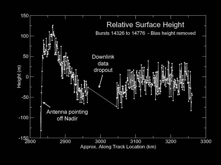
This graph, produced using preliminary altimetry data from Cassini's radar instrument, shows relative surface heights on Titan. The data were acquired on October 26, 2004, during Cassini's first close encounter with Titan, at distances ranging from 5,000 to 10,000 kilometers (3,100 to 6,200 miles). The location observed is near latitude 25 degrees north, longitude 5 degrees west. The data show a variation in height of only about 150 meters (490 feet) over the 400-kilometer-long (250-mile-long) track, indicating that in this region Titan is remarkably flat. Fine details in the data are likely to be noise, and not surface features. The area marked "downlink data dropout" was lost during transmission from the spacecraft to Earth but will be recovered by a later data replay. |