|
COMETS EARTH JUPITER KUIPER BELT MARS MERCURY METEORITES NEPTUNE OORT CLOUD PLUTO SATURN SOLAR SYSTEM SPACE SUN URANUS VENUS ORDER PRINTS
PHOTO CATEGORIES SCIENCEVIEWS AMERICAN INDIAN AMPHIBIANS BIRDS BUGS FINE ART FOSSILS THE ISLANDS HISTORICAL PHOTOS MAMMALS OTHER PARKS PLANTS RELIGIOUS REPTILES SCIENCEVIEWS PRINTS
|
Related Documents
Download Options
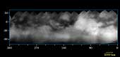
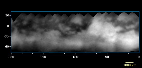
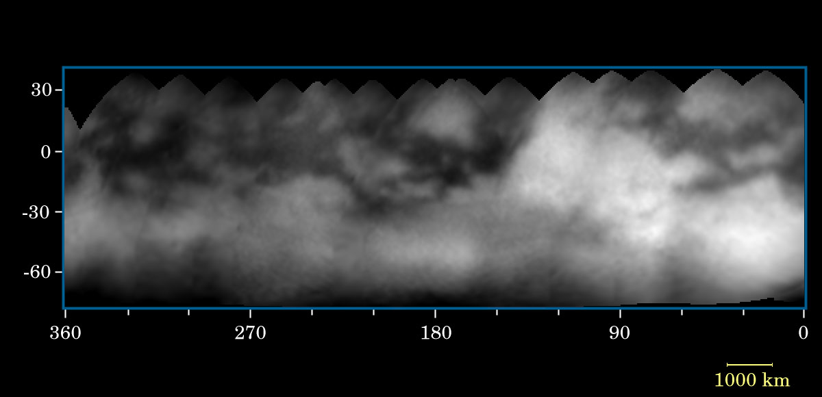
Like the mysterious dark markings on Mars that once haunted astronomer Percival Lowell, shadowy features and mysterious markings appear to stain the surface of puzzling Titan. Sixteen Cassini narrow angle camera images were used to produce the surface map shown here. The images vary in scale from 88 to 35 kilometers (52 to 21 miles) per pixel. The map has a scale of 15 kilometers (9 miles) per pixel and covers Titan's surface from latitudes of about 80 degrees south to 35 degrees north. In this map, surface features as small as about 100 kilometers (60 miles) across are clearly resolved. This is an improvement of nearly a factor of three over ground-based observations of Titan, though still too poor to understand the surface in detail. From analysis of maps such as this, it is easy to discern the characteristics of a moon's surface. The equatorial region (30 degrees south to 30 degrees north latitude) is crossed by dark markings, although they are less prominent over the bright region named "Xanadu," located near longitude 90 degrees. The map indicates that the dark markings often have relatively straight boundaries with preferred orientations - suggestive of internal, probably complex, tectonic processes. Some of the brighter, round markings might be recent impact craters, including a bright feature with rays apparently extending from it near longitude 130 degrees on the leading hemisphere of Titan. These mapped images were taken through the methane "window" at 938 nanometers with a polarizing filter. This combination was designed specifically to reduce the obscuration by atmospheric haze. This method for seeing Titan's surface was explained in an earlier release about Titan (see PIA06071). Cassini took the images between June 2 and June 22, 2004, at distances ranging from 14.8 million kilometers (9.2 million miles) to 5.9 million kilometers (3.7 million miles) from Titan. Cassini will make 45 close passes by Titan over the next four years. On July 2, 2004, Cassini will make a more-distant pass over Titan's South Pole, returning images that are 17 times higher in resolution than the best images comprising this map. |