|
COMETS EARTH JUPITER KUIPER BELT MARS MERCURY METEORITES NEPTUNE OORT CLOUD PLUTO SATURN SOLAR SYSTEM SPACE SUN URANUS VENUS ORDER PRINTS
PHOTO CATEGORIES SCIENCEVIEWS AMERICAN INDIAN AMPHIBIANS BIRDS BUGS FINE ART FOSSILS THE ISLANDS HISTORICAL PHOTOS MAMMALS OTHER PARKS PLANTS RELIGIOUS REPTILES SCIENCEVIEWS PRINTS
|
Related Document
Download Options
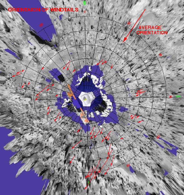
This is a representation of sediment tails noted at the Mars Pathfinder landing site. The arrows in the figure represent the inferred downwind direction, based on our understanding of the deposition of very fine sediment around surface rocks. The inferred wind direction therefore, is from the northeast blowing toward the southwest. This wind trend matched that of light and dark "streaks" of sediment in and around Martian craters in the region that have were seen by the Viking spacecraft. The detailed map was prepared by Mars Pathfinder scientists from Arizona State University on a base image created by MPF scientists from the NASA Ames research facility. Mars Pathfinder is the second in NASA's Discovery program of low-cost spacecraft with highly focused science goals. |