|
COMETS EARTH JUPITER KUIPER BELT MARS MERCURY METEORITES NEPTUNE OORT CLOUD PLUTO SATURN SOLAR SYSTEM SPACE SUN URANUS VENUS ORDER PRINTS
PHOTO CATEGORIES SCIENCEVIEWS AMERICAN INDIAN AMPHIBIANS BIRDS BUGS FINE ART FOSSILS THE ISLANDS HISTORICAL PHOTOS MAMMALS OTHER PARKS PLANTS RELIGIOUS REPTILES SCIENCEVIEWS PRINTS
|
Related Document
Download Options
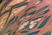
The Betsiboka is Madagascar's main river, flowing for a total of 525 kilometers (326 miles) from north of Tananarive. The river is navigable for at least 130 kilometers (81 miles) inland and the lower reaches pictured here are noted for their extensive rice fields. While the red sediment being transported provides an attractive and informative example of a river estuary, it is a symptom of an ecological disaster for Madagascar. Humans have felled and cleared the island's natural cover of tropical forest so extensively that soil erosion has been vastly accelerated. Much of the sediment visible in the river represents an irreplaceable natural asset. Brick-red lateritic soils, the result of tropical weathering, are responsible for the strong color of the sediments. Most of the deforestation in Madagascar has taken place over the last 20 years, the same period during which observations from space have been conducted. Recent observations show that very little of the original forest remains. |
